A family incident is an incident attended by Victoria Police where a Victoria Police Risk Assessment and Risk Management Report (also known as an L17 form) was completed and recorded on LEAP. For more information about counting rules, please refer to the Explanatory Notes (External link).
Aboriginal or Torres Strait Islander status for affected family members and other parties are based on the most frequent recording of the Indigenous status for each offender. Under this counting rule, a person has either a yes or no response to the Standard Indigenous Question (SIQ) on their record, then the most frequent recorded response is taken as correct. If the person only has one meaningful response, then that response stands across all records. If a person appears in the dataset two different times with a ‘yes’ and a ‘no’ in the records, a ‘yes’ response is taken over a ‘no’ response. For more information on how this counting rule operates see the Explanatory Notes (External link).
For the purposes of the presentation of these data the term Aboriginal refers to the most frequent response a person has provided to Victoria Police when the SIQ was asked (Aboriginal or Torres Strait Islander status).
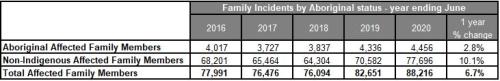
Family Incidents by Aboriginal and Torres Strait Islander status - Tabular Visualisation
Key movements in Affected Family Members by Aboriginal and Torres Strait Islander status

Demographic characteristics of affected family members by Aboriginal and Torres Strait Islander status
An ‘affected family member’ is the individual who is deemed to be affected by events occurring during a family incident. For more information about counting rules, please refer to the Explanatory Notes (External link).
In the last 12 months, 79.1% (3,524) of the 4,456 Aboriginal affected family members were female, while 20.8% (929) were male. The number of male affected family members decreased 0.2% in the last 12 months and 1.1% (10) since the year ending June 2016. Female affected family members increased 3.6% (122) in the last 12 months and 13.8% (426) since the year ending June 2016.
Affected family members by Aboriginal and Torres Strait Islander status by age and sex, year ending June 2020

In response to COVID-19 Victoria Police commenced Operation Ribbon on 13 April 2020. Operation Ribbon focused specifically on active engagement with victim-survivors and known on perpetrators of family violence and involved specialist detectives from the Family Violence Investigation Units across the state reaching out to Victorians who are at greater risk due to the COVID-19 lockdown. The recording of data related to specific police operations are often not easily identifiable in the LEAP databases. For more information about the impacts of COVID-19 on crime to end of June 2020 please see Recorded offences or the Police-recorded crime trends in Victoria during the COVID-19 pandemic.
Key movements in Other parties by Aboriginal and Torres Strait Islander status


Demographic characteristics of other parties by Aboriginal and Torres Strait Islander status
The other individual involved in a family incident is referred to as the ‘other party’. The other party could be a current partner, former partner or a family member. For more information about counting rules, please refer to the Explanatory Notes (External link).
In the last 12 months, there were 5,421 Aboriginal other parties recorded, of which 70.4% (3,816) were male and 29.6% (1,605) were female. The number of male other parties increased 1.3% (49) in the last 12 months and 11.1% (381) since the year ending June 2016. Similarly, the number of female other parties increased 12.4% (177) in the last 12 months and 29.7% (368) since the year ending June 2016.
Other parties by Aboriginal and Torres Strait Islander status by age and sex, year ending June 2020

In response to COVID-19 Victoria Police commenced Operation Ribbon on 13 April 2020. Operation Ribbon focused specifically on active engagement with victim-survivors and known on perpetrators of family violence and involved specialist detectives from the Family Violence Investigation Units across the state reaching out to Victorians who are at greater risk due to the COVID-19 lockdown. The recording of data related to specific police operations are often not easily identifiable in the LEAP databases. For more information about the impacts of COVID-19 on crime to end of June 2020 please see Recorded offences or the Police-recorded crime trends in Victoria during the COVID-19 pandemic.
 This work is licensed under a Creative Commons Attribution 4.0 International License (External link).